ISSN
ISSN 


 下载:
下载:


-
20世纪60年代以来,伴随着航空航天技术的快速发展,文献[1]首先提出遥感这一名词。遥感是指在不直接接触的情况下,对目标物或自然现象进行远距离感知的一门探测技术[2]。定量遥感或称遥感定量化,是利用遥感传感器获取地表地物的电磁波信息,在先验知识和计算机系统支持下,定量获取观测目标参量或特性的方法与技术。作为新兴的遥感信息获取与分析方法,定量遥感强调通过数学的或物理的模型将遥感信息与观测地表目标参量联系起来,定量反演或推算出某些地学目标参量[3, 4]。
但是,由于光学遥感对云雾不具有穿透性,其成像方式特点决定只能提供表层的时空信息描述,在需要对地物具有一定穿透性的应用中受到很大限制,多云雾山丘地区表现尤为明显[5]。于是,微波遥感在多云雾地区发挥着越来越重要的作用,在土地覆盖分类、土壤水分和植被生物量估算等方面取得了较好的应用效果。但是,对于植被覆盖条件下的土壤水分估算仍然存在许多问题[6]。另外,目前基于后向散射系数的森林生物量反演多基于经验模型,其普适性受到限制,并且后向散射系数在高生物量区域会存在饱和现象。干涉雷达技术发展能够提供植被的垂直结构参数,极大地提高了植被(特别是森林)生物量的反演精度[7, 8, 9, 10]。但是由于时间去相关现象在波长低于P波段的其他波段较为严重(特别是森林区域)[11, 12],而目前星载SAR数据波长都小于P波段,因此时间去相关现象严重制约了干涉SAR的应用,而预计2020年发射的P波段BIOMASS卫星则有可能解决该问题[11]。
此外,在地形起伏剧烈的山丘地区,无论是光学遥感还是微波遥感都受到地形因素的严重影响。对于光学遥感,地形主要从两方面影响光学影像,即辐射效应以及双向反射率分布函数(bidirectional reflectance distribution function, BRDF)效应[13]。辐射效应是指由于地形起伏,向阳面和背阳面接收到的入射光能量不同,从而造成遥感图像上向阳面更加明亮;BRDF效应是指地物并非朗伯体,入射角的变化会导致观测到的地物本身的反射率发生变化[14]。因此,如果不正确校正地形的影响,即便是相同特性的地物也会因为地形影响而显示出不同的波谱反射率,从而影响遥感应用的精度。目前,地形校正修正的反射率在遥感定量应用中还不太成熟,为减缓地形影响,常用的方式是利用具有波段比形式的植被指数来代替直接利用波段反射率进行研究,因为具有波段比形式的植被指数能够消除大部分的地形影响[15, 16],如归一化植被指数(normalized difference vegetation index, NDVI)、归一化红外指数(normalized difference infrared index, NDII)等。对于被动微波,地形起伏同样会引起地形坡面辐射偏差,文献[17, 18, 19]表明地形可引起约15 K的地表辐射能量变化。地形主要从两方面影响被动微波遥感[19]:1)高程的变化会改变大气中辐射传输的路径;2)倾斜坡度之间辐射的相互作用会增强有效辐射。对于主动微波遥感,地形的影响更为严重,其影响主要分为:1)几何畸变,SAR为斜距成像,地形起伏变化会导致SAR图像上透视收缩、叠掩、顶底位移和阴影等几何畸变的现象[5];2)雷达亮度的变化,地形起伏会导致地表有效散射面积的变化,从而使传感器接收到的总能量发生变化。同时,透视收缩,叠掩现象都会导致雷达亮度的改变,透视收缩使能量相对集中,从而致使该区域雷达亮度偏大。并且雷达的侧视成像原理使其更容易受到地形影响产生阴影现象,阴影区域因为没有任何回波信号,其对应SAR图像区域雷达亮度为零[20];3)局部入射角效应,如森林区域、入射角的变化会导致微波在冠层中传播路径不同,从而导致后向散射机理的变化,进一步致使获取的雷达后向散射系数的变化[21, 22]。因此有效去除地形对微波遥感影响的方法具有重要意义。
以中国西南地区(云南、贵州、四川等)为代表的多云雾山丘地区,以亚热带季风气候为主导,空气湿度大,多云雾且地形复杂,地表空间异质性强,为遥感的定量化应用带来极大的挑战和困难。综上所述,多云雾山丘地区的遥感定量化应用主要面临以下问题:1)数据时空连续性问题。云雾的干扰将严重影响光学影像的质量和数据时空连续性,导致数据缺乏,为后续基于光学遥感影像的相关研究工作带来极大的困难;而主动微波数据则因成像方式、数据共享等因素难以大范围长时间序列覆盖,在实际应用中受到很大限制。2)地形影响问题。山丘地区地形起伏严重,无论是光学数据还是微波数据都会受到严重的地形影响。地形会给光学数据同时带来辐射影响以及BRDF影响,并且会给微波数据带来几何畸变、辐射亮度变化、以及局部入射角效应的影响。3)地表空间异质性问题。山丘地区地貌复杂,地表空间异质性较强,导致在利用遥感开展定量研究工作中因地表空间异质性而引起的混合像元、尺度效应更加严重。4)病态反演问题。地表的复杂性和遥感可获取信息的有限性决定了基于物理模型的遥感反演的本质是病态反演。此外,以植被可燃物含水率(fuel moisture content, FMC)为代表的弱敏感参数由于其光谱弱敏感性,使得在异质性较强的山丘地区的反演难度更大。因此,本文在分析和总结多云雾山丘地区遥感定量化理论与方法体系基础上,对本文的研究团队近年来的相关研究进展进行介绍。
-
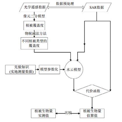
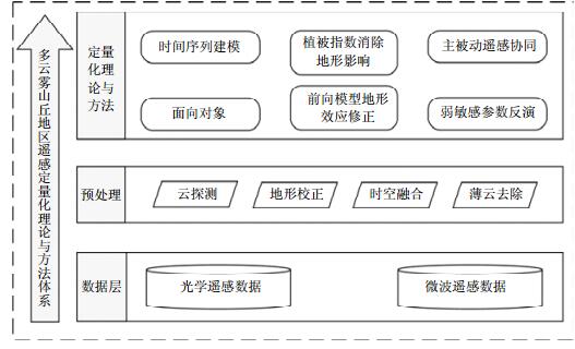
为应对上述多云雾山丘地区遥感定量化应用中面临的问题,本节分别从数据层、预处理层及定量化理论与方法层,总结分析适用于该类复杂环境地区的遥感定量化理论与方法体系,其详细结构如图 1所示。

图 1 多云雾山丘地区遥感定量化理论与方法体系结构图
1)数据方面。为应对多云雾山丘地区的数据缺乏问题,需要将多源遥感(光学/微波)数据进行综合使用,时空数据融合可同时提高数据的空间分辨率和时间分辨率。2)数据预处理方面。总结分析了目前云探测以及薄云去除常用算法;针对复杂地形问题,分别总结了光学、被动/主动微波遥感中目前地形校正的常用算法。3)定量化理论与方法方面。面向对象的反演策略用以减缓高空间异质性山丘地区的病态反演问题,主被动遥感协同提高地表参数反演的普适性和范围,植被指数消除地形影响以及前向模型地形效应修正,时间序列建模可提升地表参数的时间分辨率,弱敏感参数反演用于山丘地区森林火灾风险评估及预警。
-
目前常用的光学遥感数据大致分为多光谱数据与高光谱数据,多光谱数据可分为中低分辨率影像(数十米到公里尺度)与高分影像(分辨率达到米级或亚米级)。中低分辨率影像中较为常用的卫星传感器数据主要包括Landsat MSS/TM/ETM+/OLI数据、MODIS数据、ASTER数据、AVHRR数据、环境一星(HJ-1A/1B)等。目前,仍在轨运行的Landsat卫星传感器为Landsat ETM+与Landsat OLI/TIRS。Landsat数据在可见光与近红外波段空间分辨率为30m,热红外波段分别为60 m (ETM+)和100m (TIRS),全色波段15 m,重访周期为16天。搭载在Terra和Aqua两颗卫星上的MODIS传感器是美国地球观测系统(EOS)计划中用于观测全球生物和物理过程的重要传感器。MODIS具有36个中等空间分辨率水平(250~1 000 m)的光谱波段,每隔1~2天对地球表面观测一次。ASTER是搭载在Terra卫星上的星载热量散发和反辐射仪,共14个波段。AVHRR是NOAA系列卫星的主要探测仪器,有5个光谱波段(可见光到热红外),星下点分辨率为1.1 km,扫描角为±55.4°,幅宽达到2 800 km,因此广泛用于洲级及全球范围的研究。HJ-1A/1B数据是国产多光谱数据中的重要代表,HJ-1A星搭载了CCD相机和高光谱成像仪(HSI),HJ-1B星搭载了CCD相机和红外相机(IRS),其CCD相机提供了30 m的可见光到近红外波段数据,同时,HJ-1A与HJ-1B星还可分别提供100m与300 m的高光谱和热红外波段数据。高分影像中常用的卫星传感器主要包括IKONOS、Quick Bird、SPOT、ALOS、高分(GF)系列等。高分影像具有较高的空间分辨率和较低的光谱分辨率,因此一般用于国土资源调查、精细农业、大比例制图、城市和交通精细化管理等领域。目前常用的星载或机载高光谱传感器数据主要包括Hyperion、AVIRS、CASI、HYDICE等,其光谱分辨率达到纳米级,目前广泛应用于地质调查、精细农业、灾害监测(以重金属与水污染监测为主)等。
目前常用的微波遥感数据分为被动微波数据和主动微波数据。被动微波传感器包括:早期发射的25km空间分辨率双极化的SMMR和SSM/I传感器,SMMR有5个工作频率,SSM/I有4个工作频率;针对热带区域降雨监测的TRMM卫星上的双极化微波成像仪TMI,TMI有5个工作频率,空间分辨率从5km(85.5 GHz)至45 km(10.65 GHz);AMSR有3个系列的卫星,包括AMSR、AMSR-E、AMSR-2,其中AMSR有8个工作波段,空间分辨率为5~50 km,50.3与52.8极化方式为V极化方式,其余频率为双极化方式;AMSR-E有6个工作波段,都为双极化,其空间分辨率在5.4 km(89 GHz)至56 km(6.9 GHz)间变化,其时间覆盖范围为2002年6月18日~2011年10月4日,可用于降水率、海面温度分布、土壤湿度等参数的研究;AMSR-2有7个工作波段,都为双极化,其空间分辨率从5~50 km不等;以及专为监测全球土壤湿度和海洋表面盐度而设计的SMOS,SMOS携带着工作在L波段的干涉辐射计,其空间分辨率约为50km,并每隔3天生成全球土壤水分制图;此外还有SMAP卫星等等。主动微波星载SAR传感器包括C波段的RADARSAT-1/2雷达卫星(RADARSAT-1为HH单极化,最高空间分辨率约10 m,RADARSAT-2为全极化,最高空间分辨率为3 m);2002年发射的C波段全极化ASAR/ENVISAT,其最高空间分辨率为25m;X波段全极化TerraSAR-X的其空间分辨率达到了米级;工作波段为L波段,空间分辨率约为6m的全极化PALSAR/ALOS;以及数据免费,最高空间分辨率为5m的C波段全极化Sentinel-1A卫星,其重访周期为12天。如果与未来发射的Sentinel-1B搭配使用,重访地球一周的时间将会缩减为6天。
-
云和云阴影的存在会降低光学遥感影像的质量,从而降低了数据的利用率,在利用光学遥感数据进行相关应用前,云及云阴影的检测是预处理的重要步骤之一[23, 24, 25]。在多云雾山丘地区云及云阴影的探测显得尤为重要。
云层具有特定的物理特性,如相位、厚度和云顶温度等,其中相位由云层组成成分决定。云层厚度与电磁辐射透过率有关,云层越厚,对电磁辐射的透过率越低。云顶温度与云的高度有关,云层越高,温度越低。面向云层物理特性,先后出现了一系列针对不同传感器遥感影像的云探测方法。由于大多中分辨率传感器(如AVHRR、MODIS等)具有能够反映这些物理特性的热红外波段或者水汽/二氧化碳吸收的波段,因此文献[26, 27, 28]提出了基于中分辨率影像数据云探测方法。然而,具有更高空间分辨率的Landsat影像仅仅具有1个热红外波段和6个可见光波段。精准确地探测Landsat影像中的云层是十分困难的。其中较有代表性的两种云及云阴影检测方法为文献[24, 29]提出的针对Landsat ETM+数据的自动云覆盖估算(automatic cloud cover assessment, ACCA)方法和文献[30, 31]提出的Fmask算法。文献[24, 29]充分地利用了影像各个波段的光谱特征,采用了多组阈值分割滤波器估算云量百分比,提出了ACCA方法,该方法曾被广泛应用于Landsat图像的云量估计。然而,ACCA没有准确地提供云和云阴影的位置和边界。文献[30, 31]的Fmask算法通过基于影像的动态阈值判断云层,并结合云和云阴影几何匹配方法确定相应的云阴影。该方法目前已被应用于生产Landsat云层产品,对云及云阴影的探测效果较好。
-
云覆盖是多云雾地区光学遥感影像数据缺乏的主要原因之一。云或云阴影对地球表面的遮挡造成遥感影像上地物信息的损失,限制了遥感应用能力。文献[32]对2000~2002年内所有Landsat ETM +的历史存档数据进行研究,发现很难获得短时间内无云影像。对于多云雾地区,因长时间被云层遮挡,造成大量面积的地表信息不能被遥感卫星观测。倘若能将被云层及云阴影遮挡的区域信息复原或增强,将为不同的遥感应用研究提供良好的数据基础。常用的去云方法主要包括滤波修复法和镶嵌去云法。滤波修复法主要利用小波分析法、同态滤波法等去除低频成分,从而达到去云效果[33]。镶嵌去云法主要通过多时相遥感影像进行镶嵌拼接[34, 35],并采用辐射归一化等线性回归模型方法改正不同时相影像的辐射差异[36]。目前,Landsat、MODIS等大区域遥感影像去云大多都采用这种方法[37]。然而,不同时期的大气、光照及物候等因素存在差异,导致不同时相的遥感影像光谱差异的复杂性,无法克服不同时相影像的辐射差异。为此,文献[38]提出基于多时相影像,利用邻近像元相似性原理,并结合线性模型进行空间域的去云方法,取得了较好的效果。
-
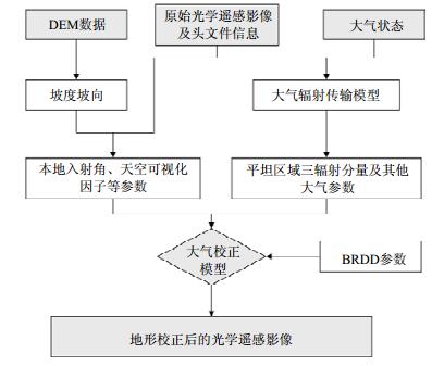
无论是光学遥感还是微波遥感都严重受到地形影响。其中,光学遥感影像地形校正流程图如图 2所示。目前光学遥感数据地形校正的方法大致可分为经验方法(如C校正法、SCS+C校正法)与物理模型校正法(如余弦校正法、图像工作站(IPW)采用的方法)。其中最成熟的算法为IPW法,把短波入射辐射分为太阳直接辐射、天空漫反射辐射以及临近像元反射辐射[39, 40, 41] 3个分量。根据光学影像成像的日期、影像位置以及成像时大气条件,可以大气辐射传输模型获取平坦区域的太阳直接辐射以及天空漫反射辐射[42, 43],之后基于数字高程模型(digital elevation model, DEM)数据获取太阳本地入射角、天空可视化因子等参数,可以求解出斜面像元的以上三辐射分量。文献[44]在假设地面为朗伯体的基础上利用了以上思路,并采用6 s大气模型实现了光学影像地形引起的辐射效应的校正。虽然该方法基于物理模型,并取得了较好的效果,但是因为其地表为朗伯体的假设致使该方法不能去除地形引起的BRDF效应。为消除BRDF效应需要获取研究区域的BRDF参数,不同学者为此提出了不同的方法,有通过经验拟合法,或者基于BRDF模型并利用MODISBRDF产品生产出研究区的BRDF参数[45, 46, 47]。之后将BRDF参数以及求取出的三辐射分量带入大气校正模型中,可以获取同时完成地形辐射效应校正以及地形BRDF效应校正的光学遥感影像[48]。

图 2 光学遥感地形校正流程图
被动微波的地形效应消除方法可分为两类,第一类是基于山区微波辐射传输物理机理的校正,首先利用地形作用于微波的物理特性来模拟山区微波辐射亮度,之后与卫星观测的亮温进行对比确定地形微波辐射亮温正向模型[49]。第二类方法是简化的地形特征统计法,因为山区地表微波辐射的复杂性,基于物理机理的方法模拟复杂,实用性较弱,因此面向实际应用多采用统计方法进行判断地形影响,并建立地形特征参数,该方法首先生成特征参数与地表亮温或者发射率之间的查找表,然后通过地形参数化来间接消除地形影响[17]。
SAR图像的地形校正分为两个部分:地形几何畸变校正及地形辐射校正。对于地形几何畸变校正,目前大致有三类方法:1)几何定位模型法,它利用卫星星历数据、SAR系统参数和地球托球体模型参数,计算得到每个像元在地球坐标系统上的位置[50];2)基于地面控制点的校正方法,主要通过选取的地面控制点构建图像空间与地理坐标之间的变换关系模型,运用该模型实现图像在地理空间坐标的定位[51, 52, 53];3)基于DEM模拟SAR的校正法,在地形起伏严重的区域,地面控制点法难以实现精确校正,此时需要DEM数据才能实现地形几何畸变的精确校正,首先基于传感器轨道参数与DEM生成模拟SAR影像,在应用图像匹配的方法对模拟影像和真实SAR影像进行配准,从而建立两者之间对应的关系;再利用模拟SAR影像与DEM之间的映射关系构建出DEM与真实SAR影像的映射关系,最终实现SAR影像的精确校正[54]。对于地形辐射校正又分为两个方面的校正,一是面积效应去除,二是局部入射角效应去除。面积效应去除需要结合地形以及雷达入射角,计算出每个像元的有效后向散射面积,之后根据有效的散射面积对雷达后向散射系数进行校正,因此精确的有效后向散射面积的获取是面积效应去除的重点[20]。除此之外,文献[55]利用Gamma面进行SAR辐射校正,将散射积分面积投影到Gamma面上,以此对后向散射系数进行归一化,并与其他传统方法对比取得了较好的效果。局部入射角效应的去除是一个很复杂的过程,与局部入射角如何影响散射机制有关,目前基于物理模型的研究较少,通常采用经验的数学模型描述后向散射系数与入射角之间的关系,然后再实际SAR图像中去掉局部入射角的影响[56]。
-
单一传感器无法兼顾高空间分辨率和高时间分辨率。结合不同分辨率的遥感影像,生成高时空分辨率的区域覆盖数据的较为有效解决办法是利用多尺度遥感数据时空融合技术。
目前时空融合模型大致可分为以下三大类:基于转换的模型、基于学习的模型、基于权重的模型。其中基于转换的模型包括了小波变换和缨帽变换[57, 58];基于学习的模型主要包括压缩感知和稀疏表达[59, 60];基于权重的模型是目前主要采用的方法,它通过计算具有相似光谱的高空间低时间分辨率遥感影像和低空间高时间分辨率遥感影像数据间临近像元信息的权重,以此产生合成高时空分辨的融合数据,该类方法凭其高精度及易用性,已成为目前主要采用的时空融合方法。文献[61]首次提出了一个空间和时间适应的反射率融合模型(spatial and temporal adaptive reflectance fusion model, STARFM),综合考虑了距离和光谱相似性以及时间差异,融合Landsat和MODIS影像生产逐天空间分辨率为16 m的合成Landsat-like数据。在此之后出现了一系列在STARFM算法上改进的算法;文献[62]提出了一个空间和时间适应性的算法(STAARCH)来绘制反射率变化影像;基于STARFM算法,文献[63]提出了一种加强的空间和时间适应反射率融合模型,考虑了传感器系统误差以及像元反射率的时间变化特征。
-
定量遥感的反演问题就是根据观测信息和前向物理模型,求解或推算描述地面实况的应用参数(或目标参数)[3]。利用卫星遥感数据大范围、多尺度、多时相的特点,对地表信息尤其是植被的各项生化参数的反演,如LAI[64, 65, 66]、叶片Cab[67, 68, 69, 70, 71]及Cw[72]等,已成为遥感应用的热点。植被参数估算的方法主要包括经验统计和物理模型方法。经验统计方法缺乏通用性且反演精度依赖于实测数据的质量、特定的植被类型和植被特定的生长环境等因素[73]。物理模型方法因其建立了植被生化参数与模型反射率之间的物理关系,而不受植被类型的影响且具有较强的普适性[74, 75]。但在应用物理模型方法在定量反演植被参数时,由于模型的输入参数较多,而一般情况下,某些输入参数难以通过遥感的手段获取,使得出现所构建方程(模型)的个数小于方程中未知数个数的问题,导致方程是欠定的,即基于物理模型的反演方法本质上是病态反演[76, 77, 78]。先验知识的引入被认为是应对病态反演问题的有效手段[78]。通过搜集研究对象的先验知识,可限定模型未知参数的取值范围,一定程度上缓解了病态反演问题[3]。因此,许多研究人员通过利用研究区实地调研或历史数据得到的先验知识,成功地反演了一些植被重要参数[79]。但是,针对某些特殊的研究区,某些参数的先验知识难于获取,或获取量有限等问题[80, 81, 82],这将增大反演结果的不确定性。面向对象的反演策略[79, 83]实质是一种空间约束,考虑到对于某一类植被(对象),在局地相同的地理、气象条件下,相邻像元间植被长势的差异并不十分明显,而是以斑块状同质像元呈现,斑块内部植被长势总体上是一致的,利用这种特点来约束植被的某些参数,可以有效地减小模型的不确定性,从而缓减模型反演的病态问题。该方法通用性较强,对先验知识要求较低,在较好的削弱病态问题的同时可以提高反演精度。
-
光学遥感数据受云雾干扰严重,特别在多云雾山丘地区,可用的遥感影像严重匮乏,而微波遥感能够穿透云雾克服云雾干扰。山丘地区多为森林覆盖,光学遥感主要表征植被表层信息,难以穿透植被冠层,致使光学遥感在监测森林生物量时容易饱和[7],而微波能够穿透植被冠层与植被内部发生作用,并到达植被下垫面,因此,微波在植被监测特别是高生物量区域以及土壤特性的监测中具有重要意义。但微波对于植被结构参数敏感,并且容易受到下垫面的影响[84],而目前在光学遥感中已有许多较成熟的算法来反演或估算森林结构参数(覆盖度(FVC)、LAI等)[85, 86],通过结合主动微波数据与被动光学数据能够提高地表参数估算精度,因此主被动协同成为了目前研究的重点[87, 88]。
目前为止已经发展了许多土壤与植被微波散射模型。土壤微波散射模型分为经验、半经验模型以及物理模型。其中经验、半经验的代表模型包括线性模型[89]、Oh模型[90],Dubois模型[91]和Shi模型[92]等。物理模型的构建主要是基于随机粗糙表面的电磁散射理论而建立的[93],目标地物的散射特性除与雷达波长、极化方式和入射角相关外,还与地物表面的粗糙度及其介电特性相关。目前主要的物理模型包括小扰动模型、基尔霍夫模型、几何光学模型、物理光学模型以及IEM/AIEM模型[84, 93]。但是以上模型都是针对裸露土壤构建的,通常情况下土壤有植被覆盖,植被将会对后向散射系数造成较大影响,因此以上土壤模型难以直接运用到植被区域。为了获得更好的效果,许多研究者利用光学数据获取的植被参数来消除植被的影响。文献[94]利用了光学数据获取了植被覆盖度、LAI等植被参数带入到水云模型中,并结合IEM模型提高了植被下土壤水分的反演精度。文献[95]对比了不同光学植被指数(LAI、VWC、NDVI、EVI等)在土壤水分反演中消除植被影响的效果。
对于植被区域,目前针对植被的模型主要包括了将植被描述为均匀介质的水云模型[96]、离散散射模型Tor Vergata模型[97, 98]、基于微波辐射传输理论密歇根微波散射模型(michigan microwave canopy scattering model, MIMICS)模型[99],该模型是目前最为完备的植被散射模型;在MIMICS模型基础上简化以适用于低矮植被的Roo模型[100]及Saatchi半经验森林散射模型等[101, 102]。植被对雷达信号的影响主要与植被冠层散射体的大小、形状、朝向以及冠层的形状覆盖度等有关,同时植被区域的下垫面的粗糙度和介电常数也会有较大影响。因此为了表征植被结构参数不同带来的影响,研究者利用光学数据获取植被参数用于植被模型中。文献[103]利用MODIS的VCF产品作为模型的重要输入参数以提取出高植被覆盖区域后向散射系数以及裸土后向散射系数,实现了森林积木积蓄量的估算。文献[104]采用了类似方法利用MODIS的VCF产品实现了森林生物量的估算。
-
在多云雾山丘地区,云雾的遮挡将严重影响光学遥感数据的质量与连续性,对单时相的遥感定量化应用带来极大困难。随着卫星对地观测网络的日益完善,以Landsat为代表的对地观测卫星可以提供长时间、周期性的遥感影像数据,使得在时间序列上对地表过程进行研究成为可能。此外,长时间序列的遥感影像还可以很好地反映植被或生态参量的时空变化规律。因此,有必要将时间序列的光学影像加以利用,建立时间序列模型,更好地服务于多云雾山丘地区的遥感定量化应用。
-
传统的土地覆盖变化监测算法大多以两个不同时期的遥感影像并采用监督或非监督分类的方式[105],利用差值、比值、典型相关变换等“分类前比较”的方法,构建差异影像,设置变化阈值,确定变化和非变化区域。尽管这类方法简单可行,但是易受到季节、气候、太阳高度、光照条件、空气状况以及传感器噪声、配准误差等因素的影响,造成光谱差异,进而增加变化监测的难度[106]。为抑制上述问题,先后出现了一系列“分类后比较”的变化监测应用研究[107, 108],即先对不同时相得到的影像单独进行分类,然后比较分类结果,确定变化的类别和变化量。这一类方法利于利用先验知识减少不同时相图像的大气和传感器差异产生的伪变化[109]。但分类的误差具有传递性,分类的误差会直接影响最后变化监测的精度[110]。为尽可能快速地检测土地利用/覆盖动态变化,许多学者开始基于长时间序列Landsat影像进行变化监测研究,并通过历史数据预测的影像数据与真实的观测数据进行连续多次的变化监测[111, 112, 113]。该类方法能够有效地抑制不同时相之间的光谱差异以及云雾遮挡的影响,十分适用于多云雾地区的土地覆盖变化监测。
-
地表的植被状态参数与生态环境参数的变化是时间连续的过程参量,因此,将长时间序列的遥感数据同化到植被生长模型和地表生态过程模型中,可以获得目标参数在时间序列上的变化信息,这比只在某个单一时间点获取植被目标参数在空间上的分布信息更具实际意义[114, 115]。数据同化技术是获取目标植被参数在时间序列上分布信息的有力手段,因此特别适用于多云雾地区的地表参数反演/估算。
数据同化最初源自数值天气预报[116],后被扩展到水文、农业及生态环境等研究领域[117, 118]。数据同化算法的基本思想可以概括为:基于最优估计理论,利用观测值(遥感观测值或实际测量数据)不断校正动态模型(陆面过程模型、作物生长模型等)的模拟值,直到没有新的观测信息为止,最终使模型在相对正确的轨迹上运行[114]。根据优化方式的区别,数据同化算法大致可以分为变分法与驱动法两类[119]。变分算法主要包括三维变分(3DVar)和四维变分(4DVar)算法,其中以四维变分为典型代表。四维变分算法[120]基于最小二乘法的原理,首先引入背景信息,构造一个测量观测值和预测值之间误差的代价函数,建立一组用于计算代价函数梯度的伴随方程;然后利用最优化算法(最速下降法、共轭梯度法等)寻找使代价函数及其梯度的最优的初始条件;接着将其输入到动态模型之中,使之运行轨迹在一个同化窗口之中达到全局最优;最终达到滤波、平滑及预测目标参数值在时间序列上的变化情况。另一种常用的数据同化算法为基于最小方差估计原理的滤波算法,其主要应用于状态变量动态模型的最优化估计中。目前常用的滤波算法为集合卡尔曼滤波算法[121],它是在卡尔曼滤波算法的基础上,针对非线性状态变量模型发展而来的最优化估计算法,而卡尔曼滤波算法只能应用于线性动态模型的最优化估计。
-
未经地形校正处理的光学遥感数据严重受到地形影响,从而在影像反射率上呈现出向阳面更高而背阳面更低的现象。因此未经过地形校正的波段反射率数据不能直接应用到山区地表参数的反演及估算中,但部分由波段运算得到的植被指数能够消除大部分的影响(如NDVI、NDII等),文献[15, 16]分析了EVI以及NDVI对于地形影响的敏感性。并指出了具有波段比形式的植被指数能够有效地消除地形影响,而EVI因为不具有波段比的形式,从而受地形影响较大。因此部分学者采用植被指数用于地表参数估算而非直接采用地表反射率。文献[122]利用NDVI对森林演替进行了监测,分析了其中的不确定性,并且指出地形因素对NDVI的影响较小。文献[123]分析了不同植被指数与LAI之间的相关性,研究表明NDVI与LAI之间的关系受地形的影响因素较小,地形校正前后的NDVI差异不大,然而SAVI与LAI之间的关系则受地形影响严重,地形校正前后的SAVI具有较大差异。究其原因是因为NDVI具有波段比的形式,所以受地形影响较小,因此与地表特性之间的关系稳定。而SAVI中的土壤调节指数导致SAVI不具有波段比的形式,从而严重受地形影响。文献[86]利用NDII指数对水分的强敏感性以及对地形、大气影响的弱敏感性实现了LFMC的反演。因此在反演及估算过程中,采用具有波段比的植被指数而非反射率同样能有效地降低地形对地表参数估算结果的影响。
-
除了在数据预处理里面对数据进行地形校正以外,针对地形引起的辐射或散射亮度的变化可以在地表前向建模中进行地形效应修正,不过该方法研究较少。文献[124]针对森林区域在几何光学模型的基础上,进行了地形对反射率影响的修正改进。几何光学模型在计算BRDF时假设地面是平面。文献[124]将入射角、视角以及所有的树木形状特性带入到斜面坐标系统中,重新计算得到了BRDF。该模型可以根据坡度和坡向直接模拟出树木的反照率。目前,在地形起伏严重的区域,若直接采用反射率进行地物参数反演估算,仍然需要对反射率进行地形校正的预处理,才能适用于目前大部分的模型。
-
在以往基于遥感的植被参数反演研究中,针对LAI、Cab、Cw等对光谱特定波段敏感的反演研究已较多,但对于重要却光谱弱敏感的植被参数反演研究较少。FMC定义为植被叶片等水分厚度(equivalent water thickness, EWT)与干物质重量(dry matter content, DMC)的比率,是表征植被点燃概率及火灾发生后传播速率的重要指标,是众多火灾预测模型的重要输入参数[125, 126]。文献[127]将辐射传输模型应用于植被FMC的反演研究中。鉴于FMC在评估野火风险及火灾传播速率方面的重要性,该方法受到了欧洲、澳大利亚、美国等野火多发国家研究人员的重视。之后,文献[128, 129, 130, 131, 132, 133]将基于辐射传输模型的FMC估算应用到了灌木、草地的FMC反演中,但相比于LAI、叶绿素、冠层含水量等参数,FMC具光谱弱敏感性问题,致使FMC的反演精度一般不高,尤其是结构较复杂的森林植被。
-
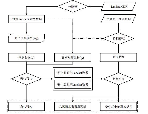
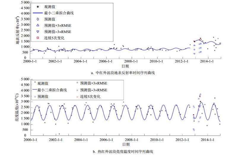
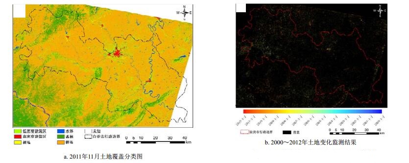
本文的研究采用文献[133]提出的基于长时间序列的方法,以四川省自贡市为研究区进行了土地覆盖变化监测,具体实验流程如图 3所示。该方法收集自贡区域长时间序列Landsat CDR数据,并利用CFmask云层产品进行云掩模,构建所有可用的时序Landsat反射率数据集。利用时间序列地表观测数据,根据不同土地覆盖类型的物候特征,对每个像素构建立相应的时间序列模型,如图 4所示,进行土地覆盖变化信息的提取。通过模型预测值与真实观测数据进行多次对比分析,判断土地覆盖类型是否发生变化。同时,基于变化前后的时序Landsat反射率数据构建时间序列模型,提取不同土地覆盖类型的季节性变化、趋势性变化等时序特征,并利用监督分类方法提取变化前后的土地覆盖类型。土地覆盖变化监测结果如图 5所示。该方法充分利用每一景Landsat影像中未被云层遮挡的地表观测值,构建时间序列模型进行土地覆盖变化信息的提取。与传统变化检测方法相比,该方法不受遥感影像质量限制,并具有较高的土地覆盖变化检测时间精度和分类精度,在多云雾地区具有较高的应用价值。

图 3 基于多源遥感数据的连续土地覆盖变化监测流程图

图 4 点(R1 258, C2 502)时间序列变化监测曲线

图 5 自贡市连续土地覆盖变化监测结果
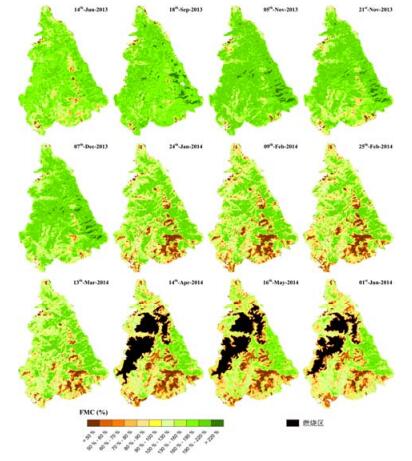
我国西南、东北及南方部分省份为森林火灾易发区,基于气象站点和人工的传统监测方法难以大面积近实时监测。基于遥感反演技术获取植被可燃物含水率(FMC),用于评估森林火灾风险具有很好的应用前景。但是,FMC自身的光谱弱敏感性特征使得基于遥感技术的FMC估算精度不高。此外,在西南地区地表空间异质性较强的森林区域存在着植被冠层分层现象,即自上而下第一层为森林冠层,第二层为低矮灌丛与草地冠层。为应对该种植被冠层分层特点,本文将PROSAIL模型与GEOSAIL模型进行耦合以模拟植被的真实分布特点,并以四川省西昌市泸山山区为研究区,选取了2013年6月~2014年6月(2014年4月泸山发生火灾)所有质量较好的Landsat-8 OLI影像进行了FMC反演,FMC的反演结果如图 6所示,预警效果良好。

图 6 四川省西昌市泸山山区在2013~2014年FMC反演结果
-
光学遥感和雷达遥感成像机理不同,在植被地上生物量反演方面各具优缺点。光学遥感难以穿透植被,只能获取植被表层信息,且容易达到饱和。雷达遥感则具有穿透植被冠层的能力,可获得植被的冠层结构信息,但却易受到下垫面影响。因此单独利用光学遥感或雷达遥感难以精确估算草原混合植被区域的生物量。文献[134]提出了一套雷达和光学遥感协同反演草原混合植被生物量的方法。该方法将光学遥感反演的植被参数作为微波散射模型的输入参数。由于混合植被区不同植被类型之间的散射机理不同,因此利用植被覆盖度,结合植被物候模型方法,将像元内整体散射贡献分为裸土贡献部分和不同类型的植被贡献部分,并结合其不同的散射机理,以此提高了植被生物量的估算精度。反演流程图如7所示。具体方法与结果参考文献[133]。

图 7 主被动遥感协同估算混合植被区植被生物量流程图
-
目前植被覆盖下土壤水分反演中最大的两个问题是如何消除植被与地表粗糙度对土壤水分反演的影响。文献[95]应用多波段多极化TerraSAR-X、RADARSAT-2和Landsat光学遥感数据,基于裸土散射模型和植被散射模型,构建了植被覆盖条件下的土壤水分主被动遥感协同反演方法。首先,采用比值方法和水云模型将植被的散射分量进行分离,其中采用不同的光学植被参数(LAI、VWC、NDVI和EVI)初始化植被模型。其次,为降低土壤水分反演对地表粗糙度的依赖,分别采用最佳粗糙度参数初始化AIEM模型和利用多极化信息化简Dubois模型,消除粗糙度参数的影响。最后,基于以上模型和方法构建了植被覆盖条件下的土壤水分主被动遥感协同反演方法。基于多极化数据的反演方法充分利用了SAR数据和光学数据各自优势,在一定程度上消除了对地表粗糙度参数的依赖,取得了较好的反演精度。实验流程如图 8所示。具体方法与结果参考文献[95]。

图 8 最佳粗糙度参数方法反演草原植被覆盖下土壤水分的流程图
-
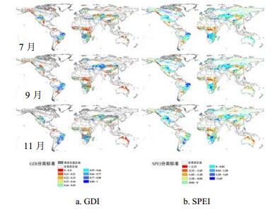
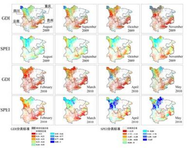
文献[134]针对草原生态系统的干旱监测构建了草原干旱指数(GDI),并同时利用了光学数据以及被动微波遥感数据,完成了每月1km的全球草原干旱指数产品生产。草原干旱指数旨在对草原大气-植被-土壤水分含量进行定量提取,并通过叠加分析以评价草原干旱情况。草原干旱指数产品生产中涉及的参数,难以单一地从光学遥感产品或者微波遥感产品中获得,因此同时结合了光学产品与微波遥感产品进行草原干旱指数产品生产。其中,区域尺度的大气含水提取采用TRMM携带的降雨雷达所获取的降雨量产品,全球尺度则采用CRU提供的降雨量数据;草原植被含水量采用草原植被冠层含水量进行表征,利用PROSAIL冠层反射率模型及优化算法进行植被冠层含水量反演;土壤含水情况由土壤水分进行定量表征,通过光学遥感产品所提供的较高分辨率的地表温度产品、NDVI产品,与粗分辨率的土壤水分产品进行多元回归分析实现尺度转换,以此获得符合空间分辨率要求的土壤水分产品。最终,通过3个参数的叠加构建草原干旱指数。图 10展示了全球GDI产品与SPEI产品的对比,图 11为GDI对2010年中国西南干旱的监测结果。具体方法与结果参考文献[135]。

图 9 2009年7、 9、 11月全球草原干旱指数产品与全球SPEI产品对比

图 10 2010年中国西南干旱GDI与SPEI监测结果对比

图 11 西南地区1982~2012年站点平均的多时间尺度SPEI值
-
近年来,我国各地不断出现干旱灾害,造成了重大损失。2010年,西南地区干旱更是被认为是百年难遇的重大干旱。为了评估其影响,文献[135]利用实测气象站点数据计算归一化降雨蒸散指数(SPEI),综合分析了西南地区1982年至2012年的干旱情况。发现西南地区近30年来有着明显变干的趋势,干旱在时间及空间上的影响也在增加。具体结果如图 11所示。同时本文还利用Global Land Data Assimilation System Version 2.0 (GLDAS-2)土壤水分产品计算土壤水分条件指数(SMCI),及AVHRR的NDVI产品计算植被条件指数(VCI)指数,验证SPEI在监测植被干旱和土壤水分方面的表现。研究表明,SPEI能够一定程度监测植被生长和土壤水分的情况,其与SMCI和VCI的相关性略高于早期的标准化降雨指数SPI。其中,VCI与SPEI和SPI的相关性都较低,这表明在相对潮湿的地区,植被的生长受降雨量影响相对较小。具体方法与结果参考文献[135]。
此外,本文的下一步工作将利用植被光学厚度(VOD)数据分析中国近些年的干旱情况。VOD产品是基于被动微波反演生产的,由于波段穿透不同,VOD反应的植被信息必然与光学植被指数不同。同时光学遥感数据受云雾干扰严重,特别是多云雾山丘地区,因此可以采用VOD产品克服云雾干扰,并进行大尺度区域监测植被干旱。
-
本文已经提到具有波段比形式的植被指数(如NDVI、NDII等)能够有效地去除地形因素的影响,但是目前常用的植被指数EVI却受地形影响严重。因此,文献[15]对EVI进行了改进,以减小地形对EVI的影响。本文分析了EVI不具有波段比形式的原因是因为其公式中土壤调节指数L,因此对土壤调节指数进行了修正,以消除地形对EVI的影响。为了避免地形校正通常存在的过度校正问题,根据数学函数的变化率,选择了合适的函数而非余弦函数对土壤调节指数进行修正。同时为了验证该方法对EVI地形因素移除的效果,选用了常用的3种地形校正算法SCS、SCS+C、MM对反射率进行校正后,再计算出EVI进行对比。结果表明,本文的方法在入射角较小的区域与其他3种方法很接近,但随着入射角的增大,其他3种方法都存在过度校正的现象,而该方法则有效地避免过度校正。并且更好地保留了NDVI所显示的地表信息。图 12展示了采用不同地形校正方法后得到的EVI结果对比。具体方法流程与结果参考文献[15]。

图 12 不同EVI与入射角余弦之间的关系
-
随着对地观测技术的飞速发展,遥感在国土、生态环境、自然灾害、智慧城市、国防等领域中发挥着越来越重要的作用。与此同时,对遥感数据及产品的精度和类别要求也越来越高,遥感应用从定性到定量是必然趋势。但是,由于地表的复杂性与遥感信息的有限性,使遥感定量应用仍存在诸多问题和挑战,特别在多云雾山丘地区表现更明显。本文首先总结分析了目前多云雾山丘地区定量遥感现状及存在的问题,指出了所存在的主要问题,包括了有效数据匮乏、云雾及地形影响、空间异质性、病态反演等。为解决以上问题,本文分别从遥感数据、数据预处理以及定量化理论与方法3个层面总结了适合多云雾山丘地区定量遥感理论及应用的方法体系。最后,结合本文的研究团队近年来的相关研究,实现了连续土地覆盖变化监测、森林可燃物含水率反演、主被动协同反演土壤水分及生物量、草原干旱指数构建及中国西南地区干旱监测等实际应用。
虽然本文较全面地总结分析了适合多云雾山丘地区遥感定量化理论及应用的方法体系,并且在实际应用中也取得了良好的效果。但是仍然存在一些有待解决的问题,如在光学遥感中,采用地形校正算法得到的反射率数据能够提高地表覆盖类型分类精度,但是却难以满足精确的地表参数反演;基于时空重构得到的数据虽然提高了遥感数据的时空分辨率,并已成功用于植被变化监测中,但是原始低空间分辨率遥感影像所不能监测出的变化,也不能在重构后的高空间分辨率遥感影像中体现出来。因此,多云雾山丘地区遥感定量化理论与方法有待进一步的深入研究和应用。
Theory and Application Status of Quantitative Remote Sensing in Cloudy and Hilly Regions
-
摘要: 在分析光学与微波遥感各自的应用现状及面临的挑战的基础上,从数据层、数据预处理和定量化理论与方法3个层面详细分析和总结了适用于多云雾山丘地区复杂环境的遥感定量化应用理论与方法,包括面向对象的反演策略、主被动遥感协同、时间序列建模、前向模型地形效应修正、弱敏感参数反演等。同时,结合研究团队近年在多云雾山丘地区遥感定量应用的研究实践,给出西南地区的土地连续变化监测、森林火灾风险评估、干旱监测、植被覆盖条件下的土壤水分主被动遥感反演等方面的应用实例。Abstract: With the rapid development of the Earth observation technologies, remote sensing plays an increasingly important role in the applications of global change, ecological environment, territorial resources, natural disasters, national defense, smart city, and other applications. Accompanied by the development and improvement for the theories and applications of the quantitative remote sensing, there are still many unprecedented challenges. Because of the Earth complexity of the surface and the limitation of the remote sensing information, the quantitative applications of remote sensing generally are hampered by ill-posed inversion, scale effect, and other problems. Especially for cloudy and hilly regions, sufficiently influenced by the cloud, topography, and spatial heterogeneity, the quantitative applications of remote sensing becomes more difficult. Based on the analysis of the application status and the challenges faced by optical and microwave remote sensing, this paper reviews the theory and approaches applied for cloudy and hilly regions from the perspective of remote sensing data, preprocessing, and the quantitative theory and approaches, which include object-oriented inversion strategy, synergy of active and passive remote sensing, time series modeling, topographic correction of the forward model, and inversion of weak sensitive parameters. In addition, specific application examples are presented based on the recent research and practice achieved by the team of the authors, including continuous change detection of land cover, forest fire risk assessment, drought monitoring, and soil moisture retrieval under vegetation cover from active and passive remote sensing in the southwest China.
-
[1] 宁津生, 陈俊勇, 李德仁, 等.测绘学概论[M].武汉:武汉大学出版社, 2008. NING Jin-sheng, CHEN Jun-yong, LI De-ren, et al. Introduction to geomatics[M]. Wuhan:Wuhan University Press, 2008. [2] 孙家抦.遥感原理与应用[M].武汉:武汉大学出版社, 2003. SUN Jia-bing. Principles and applications of remote sensing[M]. Wuhan:Wuhan University Press, 2003. [3] 李小文.定量遥感的发展与创新[J].河南大学学报(自然科学版), 2006, 35(4):49-56. http://www.cnki.com.cn/Article/CJFDTOTAL-HDZR200504011.htm LI Xiao-wen. Retrospect, prospect and innovation in quantitative remote sensing[J]. Journal of Henan University (Natural Science), 2006, 35(4):49-56. http://www.cnki.com.cn/Article/CJFDTOTAL-HDZR200504011.htm [4] 梁顺林, 李小文, 王锦地.定量遥感:理念与算法[M].北京:科学出版社, 2013. LIANG Shun-ling, LI Xiao-wen, WANG Jin-di. Quantitative remote sensing:concept and algorithm[M]. Beijing:Science Press, 2013. [5] WOODHOUSE I H. Introduction to microwave remote sensing[M]. Boca Raton:CRC Press, 2005. [6] 施建成, 杜阳, 杜今阳, 等.微波遥感地表参数反演进展[J].中国科学:地球科学, 2012, 42(6):814-42. http://www.cnki.com.cn/Article/CJFDTOTAL-JDXK201206005.htm SHI Jian-cheng, DU Yang, DU Jin-yang, et al. Progresses on microwave remotesensing of land surface parameters[J]. Science China:Earth Sciences, 2012, 42(6):814-42. http://www.cnki.com.cn/Article/CJFDTOTAL-JDXK201206005.htm [7] KOCH B. Status and future of laser scanning, synthetic aperture radar and hyperspectral remote sensing data for forest biomass assessment[J]. ISPRS Journal of Photogrammetry and Remote Sensing, 2010, 65(6):581-590. doi: 10.1016/j.isprsjprs.2010.09.001 [8] CLOUDE S, PAPATHANASSIOU K. Three-stage inversion process for polarimetric SAR interfer-ometry[C]//Radar, Sonar and Navigation, IEE Proceedings.[S.l]:IET, 2003, 150(3):125-134. [9] CLOUDE S R, PAPATHANASSIOU K P. Polarimetric SAR interferometry[J]. IEEE Transactions on Geoscience and Remote Sensing, 1998, 36(5):1551-1565. doi: 10.1109/36.718859 [10] CLOUDE S R. Polarization coherence tomography[J]. Radio Science, 2006, 41(4):1-27. [11] LE TOAN T, QUEGAN S, DAVIDSON M, et al. The BIOMASS mission:Mapping global forest biomass to better understand the terrestrial carbon cycle[J]. Remote Sensing of Environment, 2011, 115(11):2850-2860. doi: 10.1016/j.rse.2011.03.020 [12] LEE S K, KUGLER F, PAPATHANASSIOU K P, et al. Quantifying temporal decorrelation over boreal forest at L-and P-band[C]//20087th European Conference on Synthetic Aperture Radar (EUSAR). Friedrichshafen:VDE, 2008:1-4. [13] IQBAL M. An introduction to solar radiation[M]. New York, USA:Academic, 1983. [14] SOENEN S A, PEDDLE D R, COBURN C A. A modified sun-canopy-sensor topographic correction in forested terrain[J]. IEEE Transactions on Geoscience and Remote Sensing, 2005, 43(9):2148-2159. doi: 10.1109/TGRS.2005.852480 [15] LIAO Z, HE B, QUAN X. Modified enhanced vegetation index for reducing topographic effects[J]. Journal of Applied Remote Sensing, 2015, 9(1):096068-096068. doi: 10.1117/1.JRS.9.096068 [16] MATSUSHITA B, YANG W, CHEN J, et al. Sensitivity of the enhanced vegetation index (EVI) and normalized difference vegetation index (NDVI) to topographic effects:a case study in high-density cypress forest[J]. Sensors, 2007, 7(11):2636-2651. doi: 10.3390/s7112636 [17] KERR Y, SECHERRE F, LASTENET J, et al. SMOS:Analysis of perturbing effects over land surfaces[C]//2003 International Geoscience and Remote Sensing Symposium (IGARSS). Toulouse:IEEE, 2003, 2:908-910. [18] TALONE M, CAMPS A, MONERRIS A, et al. Surface topography and mixed-pixel effects on the simulated L-band brightness temperatures[J]. IEEE Transactions on Geoscience and Remote Sensing, 2007, 45(7):1996-2003. doi: 10.1109/TGRS.2007.898254 [19] TZLER M C, STANDLEY A. Technical note:relief effects for passive microwave remote sensing[J]. 2000, 21(12):2403-2412. http://cn.bing.com/academic/profile?id=2068380000&encoded=0&v=paper_preview&mkt=zh-cn [20] 张王菲.星载SAR遥感反演中地形辐射校正的关键技术研究[D].昆明:昆明理工大学, 2011. http://cdmd.cnki.com.cn/article/cdmd-10674-1012262925.htm ZHANG Wang-fei. Research on the key technologies of topographic radiation correction in satellite borne SAR remote sensing retrieval[D]. Kunming:Kunming University, 2011. http://cdmd.cnki.com.cn/article/cdmd-10674-1012262925.htm [21] CASTEL T, BEAUDOIN A, STACH N, et al. Sensitivity of space-borne SAR data to forest parameters over sloping terrain. Theory and experiment[J]. International Journal of Remote Sensing, 2001, 22(12):2351-2376. doi: 10.1080/01431160121407 [22] ULANDER L M. Radiometric slope correction of synthetic-aperture radar images[J]. IEEE Transactions on Geoscience and Remote Sensing, 1996, 34(5):1115-1122. doi: 10.1109/36.536527 [23] ARVIDSON T, GASCH J, GOWARD S N. Landsat 7's long-term acquisition plan-an innovative approach to building a global imagery archive[J]. Remote Sensing of Environment, 2001, 78(1):13-26. http://cn.bing.com/academic/profile?id=2015135807&encoded=0&v=paper_preview&mkt=zh-cn [24] IRISH R R. Landsat 7 automatic cloud cover assessment[C]//International Society for Optics and Photonics. Bellingham:SPIE, 2000:348-355. [25] SIMPSON J J, STITT J R. A procedure for the detection and removal of cloud shadow from AVHRR data over land[J]. IEEE Transactions on Geoscience and Remote Sensing, 1998, 36(3):880-897. doi: 10.1109/36.673680 [26] SAUNDERS R W, KRIEBEL K T. An improved method for detecting clear sky and cloudy radiances from AVHRR data[J]. International Journal of Remote Sensing, 1988, 9(1):123-150. doi: 10.1080/01431168808954841 [27] DERRIEN M, FARKI B, HARANG L, et al. Automatic cloud detection applied to NOAA-11/AVHRR imagery[J]. Remote Sensing of Environment, 1993, 46(3):246-267. doi: 10.1016/0034-4257(93)90046-Z [28] ACKERMAN S A, STRABALA K I, MENZEL W P, et al. Discriminating clear sky from clouds with MODIS[J]. Journal of Geophysical Research:Atmospheres (1984-2012), 1998, 103(D24):32141-32157. doi: 10.1029/1998JD200032 [29] IRISH R R, BARKER J L, GOWARD S N, et al. Characterization of the Landsat-7 ETM+ automated cloud-cover assessment (ACCA) algorithm[J]. Photo-Grammetric Engineering & Remote Sensing, 2006, 72(10):1179-1188. http://cn.bing.com/academic/profile?id=2166251851&encoded=0&v=paper_preview&mkt=zh-cn [30] ZHU Z, WOODCOCK C E. Object-based cloud and cloud shadow detection in Landsat imagery[J]. Remote Sensing of Environment, 2012, 118(6):83-94. http://cn.bing.com/academic/profile?id=2028240797&encoded=0&v=paper_preview&mkt=zh-cn [31] ZHU Z, WANG S, WOODCOCK C E. Improvement and expansion of the Fmask algorithm:Cloud, cloud shadow, and snow detection for Landsats 4-7, 8, and Sentinel 2 images[J]. Remote Sensing of Environment, 2015, 159:269-277. doi: 10.1016/j.rse.2014.12.014 [32] JU J, ROY D P. The availability of cloud-free Landsat ETM+ data over the conterminous United States and globally[J]. Remote Sensing of Environment, 2008, 112(3):1196-1211. doi: 10.1016/j.rse.2007.08.011 [33] MAALOUF A, CARR P, AUGEREAU B, et al. A bandelet-based inpainting technique for clouds removal from remotely sensed images[J]. IEEE Transactions on Geoscience and Remote Sensing, 2009, 47(7):2363-2371. doi: 10.1109/TGRS.2008.2010454 [34] ROY D P, JU J, LEWIS P, et al. Multi-temporal MODIS-Landsat data fusion for relative radiometric normalization, gap filling, and prediction of Landsat data[J]. Remote Sensing of Environment, 2008, 112(6):3112-3130. doi: 10.1016/j.rse.2008.03.009 [35] HAGOLLE O, HUC M, PASCUAL D V, et al. A multi-temporal method for cloud detection, applied to FORMOSAT-2, VENμS, LANDSAT and SENTINEL-2 images[J]. Remote Sensing of Environment, 2010, 114(8):1747-1755. doi: 10.1016/j.rse.2010.03.002 [36] HELMER E H, RUEFENACHT B. A comparison of radiometric normalization methods when filling cloud gaps in Landsat imagery[J]. Canadian Journal of Remote Sensing, 2007, 33(4):325-340. doi: 10.5589/m07-028 [37] TSENG D C, TSENG H T, CHIEN C L. Automatic cloud removal from multi-temporal SPOT images[J]. Applied Mathematics and Computation, 2008, 205(2):584-600. doi: 10.1016/j.amc.2008.05.050 [38] ZHU X, GAO F, LIU D, et al. A modified neighborhood similar pixel interpolator approach for removing thick clouds in Landsat images[J]. IEEE Geoscience and Remote Sensing Letters, 2012, 9(3):521-525. doi: 10.1109/LGRS.2011.2173290 [39] LIANG S. Quantitative remote sensing of land surfaces[M]. Hoboken:John Wiley & Sons, 2005. [40] DOZIER J, FREW J. Atmospheric corrections to satellite radiometric data over rugged terrain[J]. Remote Sensing of Environment, 1981, 11:191-205. doi: 10.1016/0034-4257(81)90019-5 [41] DOZIER J, FREW J. Rapid calculation of terrain parameters for radiation modeling from digital elevation data[J]. IEEE Transactions on Geoscience and Remote Sensing, 1990, 28(5):963-969. doi: 10.1109/36.58986 [42] VERMOTE E F, TANR D, DEUZ J L, et al. Second simulation of the satellite signal in the solar spectrum, 6S:an overview[J]. IEEE Transactions on Geoscience and Remote Sensing, 1997, 35(3):675-686. doi: 10.1109/36.581987 [43] VERMOTE E, TANR D, DEUZ J, et al. Second simulation of a satellite signal in the solar spectrum-vector (6SV)[J]. 6S User Guide Version, 2006, 3:1-55. https://www.researchgate.net/profile/Jean_Jacques_Morcrette/publication/247461276_Second_simulation_of_a_satellite_signal_in_the_solar_spectrum-vector_6SV/links/548eb79a0cf2d1800d8448c3.pdf?inViewer=0&pdfJsDownload=0&origin=publication_detail [44] SANDMEIER S, ITTEN K I. A physically-based model to correct atmospheric and illumination effects in optical satellite data of rugged terrain[J]. IEEE Transactions on Geoscience and Remote Sensing, 1997, 35(3):708-717. doi: 10.1109/36.581991 [45] SHUAI Y, MASEK J G, GAO F, et al. An algorithm for the retrieval of 30 m snow-free albedo from Landsat surface reflectance and MODIS BRDF[J]. Remote Sensing of Environment, 2011, 115(9):2204-2216. doi: 10.1016/j.rse.2011.04.019 [46] LI F, JUPP D L, REDDY S, et al. An evaluation of the use of atmospheric and BRDF correction to standardize Landsat data[J]. IEEE Journal of Selected Topics in Applied Earth Observations and Remote Sensing, 2010, 3(3):257-270. doi: 10.1109/JSTARS.2010.2042281 [47] WEN J, LIU Q, LIU Q, et al. Parametrized BRDF for atmospheric and topographic correction and albedo estimation in Jiangxi rugged terrain, China[J]. International Journal of Remote Sensing, 2009, 30(11):2875-2896. doi: 10.1080/01431160802558618 [48] LI F, JUPP D L, THANKAPPAN M, et al. A physics-based atmospheric and BRDF correction for landsat data over mountainous terrain[J]. Remote Sensing of Environment, 2012, 124:756-770. doi: 10.1016/j.rse.2012.06.018 [49] PIERDICCA N, PULVIRENTI L, MARZANO F S. Simulating topographic effects on spaceborne radiometric observations between L and X frequency bands[J]. IEEE Transactions on Geoscience and Remote Sensing, 2010, 48(1):273-282. doi: 10.1109/TGRS.2009.2028881 [50] CURLANDER J C. Location of spaceborne SAR imagery[J]. IEEE Transactions on Geoscience and Remote Sensing, 1982(3):359-364. http://cn.bing.com/academic/profile?id=2057517948&encoded=0&v=paper_preview&mkt=zh-cn [51] TOUTIN T. Review article:Geometric processing of remote sensing images:models, algorithms and methods[J]. International Journal of Remote Sensing, 2004, 25(10):1893-1924. doi: 10.1080/0143116031000101611 [52] LEBERL F W. Radargrammetric image processing[M]. Landon:Artech House, 1990, [53] KONECNY G, SCHUHR W. Reliability of radar image data[C]//1988 International Society for Photogrammetry and Remote Sensing (ISPRS) Congress. Kyoto:Elsevier, 1988. [54] JOHNSEN H, LAUKNES L, GUNERIUSSEN T. Geocoding of fast-delivery ERS-l SAR image mode product using DEM data[J]. International Journal of Remote Sensing, 1995, 16(11):1957-1968. doi: 10.1080/01431169508954532 [55] SMALL D. Flattening gamma:Radiometric terrain correction for SAR imagery[J]. IEEE Transactions on Geoscience and Remote Sensing, 2011, 49(8):3081-3093. doi: 10.1109/TGRS.2011.2120616 [56] 李震, 廖静娟.合成孔径雷达地表参数反演模型与方法[M].北京:科学出版社, 2011. LI Zhen, LIAO Jing-juan. Land surface parameter inversion model and method for synthetic aperture radar[M]. Beijing:Science Press, 2013. [57] ACERBI-JUNIOR F, CLEVERS J, SCHAEPMAN M. The assessment of multi-sensor image fusion using wavelet transforms for mapping the Brazilian Savanna[J]. International Journal of Applied Earth Observation and Geoinformation, 2006, 8(4):278-288. doi: 10.1016/j.jag.2006.01.001 [58] HILKER T, WULDER M A, COOPS N C, et al. A new data fusion model for high spatial-and temporal-resolution mapping of forest disturbance based on Landsat and MODIS[J]. Remote Sensing of Environment, 2009, 113(8):1613-1627. doi: 10.1016/j.rse.2009.03.007 [59] YANG J, WRIGHT J, HUANG T S, et al. Image super-resolution via sparse representation[J]. IEEE Transactions on Image Processing, 2010, 19(11):2861-2873. doi: 10.1109/TIP.2010.2050625 [60] SONG H, HUANG B. Spatiotemporal satellite image fusion through one-pair image learning[J]. IEEE Transactions on Geoscience and Remote Sensing, 2013, 51(4):1883-1896. doi: 10.1109/TGRS.2012.2213095 [61] GAO F, MASEK J, SCHWALLER M, et al. On the blending of the Landsat and MODIS surface reflectance:Predicting daily Landsat surface reflectance[J]. IEEE Transactions on Geoscience and Remote Sensing, 2006, 44(8):2207-2218. doi: 10.1109/TGRS.2006.872081 [62] HILKER T, WULDER M A, COOPS N C, et al. Generation of dense time series synthetic Landsat data through data blending with MODIS using a spatial and temporal adaptive reflectance fusion model[J]. Remote Sensing of Environment, 2009, 113(9):1988-1999. doi: 10.1016/j.rse.2009.05.011 [63] ZHU X, CHEN J, GAO F, et al. An enhanced spatial and temporal adaptive reflectance fusion model for complex heterogeneous regions[J]. Remote Sensing of Environ-ment, 2010, 114(11):2610-2623. doi: 10.1016/j.rse.2010.05.032 [64] 杨燕, 田庆久.水稻LAI参数的Hyperion反演研究[J].遥感技术与应用, 2007, 22(3):345-350. http://www.cnki.com.cn/Article/CJFDTOTAL-YGJS200703008.htm YANG Yan, TIAN Qing-jiu. The study of deducing leaf area index of rice of hyperion[J]. Remote Sensing Technology and Application, 2007, 22(3):345-350. http://www.cnki.com.cn/Article/CJFDTOTAL-YGJS200703008.htm [65] 陈健, 倪绍祥, 李云梅.基于神经网络方法的芦苇叶面积指数遥感反演[J].国土资源遥感, 2008, 72(2):62-67. http://www.cnki.com.cn/Article/CJFDTOTAL-GTYG200802014.htm CHEN Jian, NI Shao-xiang, LI Yun-mei. LAI retrieval of reed canopy using the neural network method[J]. Remote Sensing for Land & Resources, 2008, 72(2):62-67. http://www.cnki.com.cn/Article/CJFDTOTAL-GTYG200802014.htm [66] BROUGHAM R. The relationship between the critical leaf area, total chlorophyll content, and maximum growth-rate of some pasture and crop planst[J]. Annals of Botany, 1960, 24(4):463-474. http://cn.bing.com/academic/profile?id=2136942826&encoded=0&v=paper_preview&mkt=zh-cn [67] BANNARI A, KHURSHID K S, STAENZ K, et al. A comparison of hyperspectral chlorophyll indices for wheat crop chlorophyll content estimation using laboratory reflectance measurements[J]. IEEE Transactions on Geoscience and Remote Sensing, 2007, 45(10):3063-3074. doi: 10.1109/TGRS.2007.897429 [68] SI Y, SCHLERF M, ZURITA-MILLA R, et al. Mapping spatio-temporal variation of grassland quantity and quality using MERIS data and the PROSAIL mode[J]. Remote Sensing of Environment, 2012, 121:415-425. doi: 10.1016/j.rse.2012.02.011 [69] CURRAN P J, EDWARD J M. The relationships between the chlorophyll concentration, LAI and reflectance of a simple vegetation canopy[J]. International Journal of Remote Sensing, 1983, 4(2):247-255. doi: 10.1080/01431168308948544 [70] GITELSON A A, VINA A, CIGANDA V, et al. Remote estimation of canopy chlorophyll content in crops[J]. Geophysical Research Letters, 2005, 32(8):1-4. http://cn.bing.com/academic/profile?id=2109006150&encoded=0&v=paper_preview&mkt=zh-cn [71] 乔振民, 邢立新, 李淼淼, 等. Hyperion数据玉米叶绿素含量制图[J].遥感技术与应用, 2012, 27(2):275-281. http://www.cnki.com.cn/Article/CJFDTOTAL-YGJS201202017.htm QIAO Zhen-min, XING Li-xin, LI Miao-miao, et al. Mapping of maize chlorophyll content with hyperion data[J]. Remote Sensing Technology and Application, 2012, 27(2):275-281. http://www.cnki.com.cn/Article/CJFDTOTAL-YGJS201202017.htm [72] TUCKER C J. Remote sensing of leaf water content in the near infrared[J]. Remote Sensing of Environment, 1980, 10(1):23-32. doi: 10.1016/0034-4257(80)90096-6 [73] DARVISHZADEH R, SKIDMORE A, SCHLERF M, et al. Inversion of a radiative transfer model for estimating vegetation LAI and chlorophyll in a heterogeneous grassland[J]. Remote Sensing of Environment, 2008, 112(5):2592-604. doi: 10.1016/j.rse.2007.12.003 [74] HE B, QUAN X, XING M. Retrieval of leaf area index in alpine wetlands using a two-layer canopy reflectance model[J]. International Journal of Applied Earth Observation and Geoinformation, 2013, 21:78-91. doi: 10.1016/j.jag.2012.08.014 [75] CHEN X, AN S, CHEN J, et al. A review on forest ecosystem biophysical parameter retrieval from remotely sensed data[J]. Chin J Ecol, 2005, 24(9):1074-1079. http://cn.bing.com/academic/profile?id=2351552346&encoded=0&v=paper_preview&mkt=zh-cn [76] COMBAL B, BARET F, WEISS M. Improving canopy variables estimation from remote sensing data by exploiting ancillary information. Case study on sugar beet canopies[J]. Agronomie, 2002, 22(2):205-215. doi: 10.1051/agro:2002008 [77] COMBAL B, BARET F, WEISS M, et al. Retrieval of canopy biophysical variables from bidirectional reflectance:Using prior information to solve the ill-posed inverse problem[J]. Remote Sensing of Environment, 2003, 84(1):1-15. doi: 10.1016/S0034-4257(02)00035-4 [78] 李小文, 王锦地, 胡宝新, 等.先验知识在遥感反演中的作用[J].中国科学:D辑, 1998, 28(1):67-72. http://www.cnki.com.cn/Article/CJFDTOTAL-JDXK199801011.htm LI Xiao-wen, WANG Jin-di, HU Bao-xin, et al. On utilization of a priori knowledge in inversion of remote sensing models[J]. Science China (Series D), 1998, 28(1):67-72. http://www.cnki.com.cn/Article/CJFDTOTAL-JDXK199801011.htm [79] ATZBERGER C. Object-based retrieval of biophysical canopy variables using artificial neural nets and radiative transfer models[J]. Remote Sensing of Environment, 2004, 93(1):53-67. http://cn.bing.com/academic/profile?id=2030078894&encoded=0&v=paper_preview&mkt=zh-cn [80] 阎广建, 吴均.光谱先验知识在植被结构遥感反演中的应用[J].遥感学报, 2002, 6(1):1-6. http://www.cnki.com.cn/Article/CJFDTOTAL-YGXB200201000.htm YAN Guang-jian, WU Jun. Spectral prior knowledge and its use in the remote sensing based inversion of vegetation structure[J]. Journal of Remote Sensing, 2002, 6(1):1-6. http://www.cnki.com.cn/Article/CJFDTOTAL-YGXB200201000.htm [81] 蔡博峰, 绍霞.基于PROSPECT+ SAIL模型的遥感叶面积指数反演[J].国土资源遥感, 2007, 2:39-43. http://www.cnki.com.cn/Article/CJFDTOTAL-GTYG200702011.htm CAI Bo-feng, SHAO Xia. Leaf area index retrieval based on remotely sensed data and PROSPECT+ SAIL model[J]. Remote Sensing For Land & Resources, 2007, 2:39-43. http://www.cnki.com.cn/Article/CJFDTOTAL-GTYG200702011.htm [82] ATZBERGER C, RICHTER K. Spatially constrained inversion of radiative transfer models for improved LAI mapping from future Sentinel-2 imagery[J]. Remote Sensing of Environment, 2012, 120:208-218. doi: 10.1016/j.rse.2011.10.035 [83] 行敏锋.生态脆弱区植被生物量和土壤水分的主被动遥感协同反演[D].成都:电子科技大学, 2015. XING Min-feng. Integration study to retrieve vegetation biomass and soil moisture simultaneously using active and passive remote sensing data in ecologically vulnerable area[D]. Chengdu:University of Electronic Science and Technology of China, 2015. [84] LEPRIEUR C, VERSTRAETE M M, PINTY B. Evaluation of the performance of various vegetation indices to retrieve vegetation cover from AVHRR data[J]. Remote Sensing Reviews, 1994, 10(4):265-284. doi: 10.1080/02757259409532250 [85] QUAN X, HE B, LI X, et al. Retrieval of grassland live fuel moisture content by parameterizing radiative transfer model with interval estimated LAI[J]. IEEE Journal of Selected Topics in Applied Earth Observations and Remote Sensing, 2016, 9(2):910-920. doi: 10.1109/JSTARS.2015.2472415 [86] MONTESANO P, COOK B, SUN G, et al. Achieving accuracy requirements for forest biomass mapping:a spaceborne data fusion method for estimating forest biomass and LiDAR sampling error[J]. Remote Sensing of Environment, 2013, 130:153-170. doi: 10.1016/j.rse.2012.11.016 [87] RAUSTE Y. Multi-temporal JERS SAR data in boreal forest biomass mapping[J]. Remote Sensing of Environ-ment, 2005, 97(2):263-275. doi: 10.1016/j.rse.2005.05.002 [88] ZRIBI M, BAGHDADI N, HOLAH N, et al. New methodology for soil surface moisture estimation and its application to ENVISAT-ASAR multi-incidence data inversion[J]. Remote Sensing of Environment, 2005, 96(3):485-496. http://cn.bing.com/academic/profile?id=2163470201&encoded=0&v=paper_preview&mkt=zh-cn [89] OH Y, SARABANDI K, ULABY F T. An empirical model and an inversion technique for radar scattering from bare soil surfaces[J]. IEEE Transactions on Geoscience and Remote Sensing, 1992, 30(2):370-381. doi: 10.1109/36.134086 [90] DUBOIS P C, VAN ZYL J, ENGMAN T. Measuring soil moisture with imaging radars[J]. IEEE Transactions on Geoscience and Remote Sensing, 1995, 33(4):915-926. doi: 10.1109/36.406677 [91] SHI J, WANG J, HSU A Y, et al. Estimation of bare surface soil moisture and surface roughness parameter using L-band SAR image data[J]. IEEE Transactions on Geoscience and Remote Sensing, 1997, 35(5):1254-1266. doi: 10.1109/36.628792 [92] FUNG A K, LI Z, CHEN K-S. Backscattering from a randomly rough dielectric surface[J]. IEEE Transactions on Geoscience and Remote Sensing, 1992, 30(2):356-369. doi: 10.1109/36.134085 [93] HE B, XING M, BAI X. A synergistic methodology for soil moisture estimation in an Alpine prairie using radar and optical satellite data[J]. Remote Sensing, 2014, 6(11):10966-10985. doi: 10.3390/rs61110966 [94] BAI X, HE B, LI X. Optimum surface roughness to parameterize advanced integral equation model for soil moisture retrieval in prairie area using radarsat-2 data[J]. IEEE Transactions on Geoscience and Remote Sensing, 2016, 54(4):2437-2449. doi: 10.1109/TGRS.2015.2501372 [95] ATTEMA E, ULABY F T. Vegetation modeled as a water cloud[J]. Radio Science, 1978, 13(2):357-364. doi: 10.1029/RS013i002p00357 [96] BRACAGLIA M, FERRAZZOLI P, GUERRIERO L. A fully polarimetric multiple scattering model for crops[J]. Remote Sensing of Environment, 1995, 54(3):170-179. doi: 10.1016/0034-4257(95)00151-4 [97] FERRAZZOLI P, GUERRIERO L. Emissivity of vegetation:Theory and computational aspects[J]. Journal of Electromagnetic Waves and Applications, 1996, 10(5):609-628. doi: 10.1163/156939396X00559 [98] ULABY F T, SARABANDI K, MCDONALD K, et al. Michigan microwave canopy scattering model[J]. International Journal of Remote Sensing, 1990, 11(7):1223-1253. doi: 10.1080/01431169008955090 [99] DE ROO R D, DU Y, ULABY F T, et al. A semi-empirical backscattering model at L-band and C-band for a soybean canopy with soil moisture inversion[J]. IEEE Transactions on Geoscience and Remote Sensing, 2001, 39(4):864-872. doi: 10.1109/36.917912 [100] SAATCHI S S, MOGHADDAM M. Estimation of crown and stem water content and biomass of boreal forest using polarimetric SAR imagery[J]. IEEE Transactions on Geoscience and Remote Sensing, 2000, 38(2):697-709. doi: 10.1109/36.841999 [101] SAATCHI S S, MCDONALD K C. Coherent effects in microwave backscattering models for forest canopies[J]. IEEE Transactions on Geoscience and Remote Sensing, 1997, 35(4):1032-1044. doi: 10.1109/36.602545 [102] SANTORO M, BEER C, CARTUS O, et al. Retrieval of growing stock volume in boreal forest using hyper-temporal series of Envisat ASAR ScanSAR backscatter measurements[J]. Remote Sensing of Environment, 2011, 115(2):490-507. doi: 10.1016/j.rse.2010.09.018 [103] CARTUS O, SANTORO M, KELLNDORFER J. Mapping forest aboveground biomass in the Northeastern United States with ALOS PALSAR dual-polarization L-band[J]. Remote Sensing of Environment, 2012, 124:466-478. doi: 10.1016/j.rse.2012.05.029 [104] STOW D, HAMADA Y, COULTER L, et al. Monitoring shrubland habitat changes through object-based change identification with airborne multispectral imagery[J]. Remote Sensing of Environment, 2008, 112(3):1051-1061. doi: 10.1016/j.rse.2007.07.011 [105] 马建伟.全色波段高空间分辨遥感影像特定目标变化检测技术研究[D].北京:中国科学院遥感应用研究所, 2006. http://cdmd.cnki.com.cn/article/cdmd-80070-2006157799.htm MA Jian-wei. Change detection of specified targetin high spatial resolution panchromatic imagery[D]. Beijing:Insitute of Remote Sensing Applications Chinese Academy of Sciences, 2006. http://cdmd.cnki.com.cn/article/cdmd-80070-2006157799.htm [106] READ J M, LAM N S N. Spatial methods for characterising land cover and detecting land-cover changes for the tropics[J]. International Journal of Remote Sensing, 2002, 23(12):2457-2474. doi: 10.1080/01431160110106140 [107] KEUCHEL J, NAUMANN S, HEILER M, et al. Automatic land cover analysis for Tenerife by supervised classification using remotely sensed data[J]. Remote Sensing of Environment, 2003, 86(4):530-541. doi: 10.1016/S0034-4257(03)00130-5 [108] BRUZZONE L, PRIETO D F. Unsupervised retraining of a maximum likelihood classifier for the analysis of multitemporal remote sensing images[J]. IEEE Transactions on Geoscience and Remote Sensing, 2001, 39(2):456-460. doi: 10.1109/36.905255 [109] FULLER R, SMITH G, DEVEREUX B. The characterisation and measurement of land cover change through remote sensing:problems in operational applications?[J]. International Journal of Applied Earth Observation and Geoinformation, 2003, 4(3):243-253. doi: 10.1016/S0303-2434(03)00004-7 [110] ZHU Z, WOODCOCK C E, OLOFSSON P. Continuous monitoring of forest disturbance using all available Landsat imagery[J]. Remote Sensing of Environment, 2012, 122:75-91. doi: 10.1016/j.rse.2011.10.030 [111] HUANG C, GOWARD S N, MASEK J G, et al. An automated approach for reconstructing recent forest disturbance history using dense Landsat time series stacks[J]. Remote Sensing of Environment, 2010, 114(1):183-198. doi: 10.1016/j.rse.2009.08.017 [112] ZHU Z, WOODCOCK C E. Continuous change detection and classification of land cover using all available Landsat data[J]. Remote Sensing of Environment, 2014, 144:152-171. doi: 10.1016/j.rse.2014.01.011 [113] 全兴文.高原湿地植被参数遥感定量反演及同化技术研究[D].成都:电子科技大学, 2013. http://cdmd.cnki.com.cn/article/cdmd-10614-1013334344.htm QUAN Xing-wen. Quantitative retrieval methods anddata assimilation technology forvegetational parameters in alpinewetland[D]. Chengdu:University of Electronic Science and Technology of China, 2013. http://cdmd.cnki.com.cn/article/cdmd-10614-1013334344.htm [114] 柳钦火.环境遥感定量反演与同化[M].北京:科学出版社, 2011. LIU Qin-huo. Quantitative retrieval and assimilation of environmental remote sensing[M]. Beijing:Science Press, 2011. [115] CHARNEY J, HALEM M, JASTROW R. Use of incomplete historical data to infer the present state of the atmosphere[J]. Journal of the Atmospheric Sciences, 1969, 26(5):1160-1163. doi: 10.1175/1520-0469(1969)026<1160:UOIHDT>2.0.CO;2 [116] NOUVELLON Y, MORAN M S, SEEN D L, et al. Coupling a grassland ecosystem model with Landsat imagery for a 10-year simulation of carbon and water budgets[J]. Remote Sensing of Environment, 2001, 78(1):131-149. http://cn.bing.com/academic/profile?id=2057680602&encoded=0&v=paper_preview&mkt=zh-cn [117] WEISS M, TROUFLEAU D, BARET F, et al. Coupling canopy functioning and radiative transfer models for remote sensing data assimilation[J]. Agricultural and Forest Meteorology, 2001, 108(2):113-128. doi: 10.1016/S0168-1923(01)00234-9 [118] TALAGRAND O. Assimilation of observations, an introduction[J]. Journal-Meteorological Society of Japan Series 2, 1997, 75:81-99. http://cn.bing.com/academic/profile?id=85093244&encoded=0&v=paper_preview&mkt=zh-cn [119] RABIER F. Overview of global data assimilation developments in numerical weather-prediction centres[J]. Quarterly Journal of the Royal Meteorological Society, 2005, 131(613):3215-3233. doi: 10.1256/qj.05.129 [120] QUAN X, HE B, XING M. Use of data assimilation technique for improveing the retrieval of leaf area index in time-series in alpine wetlands[C]//2012 International Geoscience and Remote Sensing Symposium (IGARSS). Munich:IEEE, 2012:754-756. [121] SONG C, WOODCOCK C E. Monitoring forest succession with multitemporal Landsat images:Factors of uncertainty[J]. IEEE Transactions on Geoscience and Remote Sensing, 2003, 41(11):2557-2567. doi: 10.1109/TGRS.2003.818367 [122] TURNER D P, COHEN W B, KENNEDY R E, et al. Relationships between leaf area index and Landsat TM spectral vegetation indices across three temperate zone sites[J]. Remote Sensing of Environment, 1999, 70(1):52-68. doi: 10.1016/S0034-4257(99)00057-7 [123] SCHAAF C B, LI X, STRAHLER A H. Topographic effects on bidirectional and hemispherical reflectances calculated with a geometric-optical canopy model[J]. IEEE Transactions on Geoscience and Remote Sensing, 1994, 32(6):1186-1193. doi: 10.1109/36.338367 [124] YEBRA M, DENNISON P E, CHUVIECO E, et al. A global review of remote sensing of live fuel moisture content for fire danger assessment:Moving towards operational products[J]. Remote Sensing of Environment, 2013, 136:455-468. doi: 10.1016/j.rse.2013.05.029 [125] DANSON F, BOWYER P. Estimating live fuel moisture content from remotely sensed reflectance[J]. Remote Sensing of Environment, 2004, 92(3):309-321. doi: 10.1016/j.rse.2004.03.017 [126] RIANO D, VAUGHAN P, CHUVIECO E, et al. Estimation of fuel moisture content by inversion of radiative transfer models to simulate equivalent water thickness and dry matter content:Analysis at leaf and canopy level[J]. IEEE Transactions on Geoscience and Remote Sensing, 2005, 43(4):819-826. doi: 10.1109/TGRS.2005.843316 [127] YEBRA M, CHUVIECO E, RIANO D. Estimation of live fuel moisture content from MODIS images for fire risk assessment[J]. Agr Forest Meteorol, 2008, 148(4):523-536. doi: 10.1016/j.agrformet.2007.12.005 [128] YEBRA M, CHUVIECO E. Generation of a species-specific look-up table for fuel moisture content assessment[J]. IEEE J Sel Top Appl Earth Observ Remote Sens, 2009, 2(1):21-26. doi: 10.1109/JSTARS.2009.2014008 [129] YEBRA M, CHUVIECO E. Linking ecological information and radiative transfer models to estimate fuel moisture content in the mediterranean region of Spain:Solving the ill-posed inverse problem[J]. Remote Sensing of Environment, 2009, 113(11):2403-2411. doi: 10.1016/j.rse.2009.07.001 [130] JURDAO S, YEBRA M, GUERSCHMAN J P, et al. Regional estimation of woodland moisture content by inverting radiative transfer models[J]. Remote Sensing of Environment, 2013, 132:59-70. doi: 10.1016/j.rse.2013.01.004 [131] YEBRA M, DENNISON P E, CHUVIECO E, et al. A global review of remote sensing of live fuel moisture content for fire danger assessment:Moving towards operational products[J]. Remote Sensing of Environment, 2013, 136:455-468. doi: 10.1016/j.rse.2013.05.029 [132] WANG L L, HUNT E R, QU J J, et al. Remote sensing of fuel moisture content from ratios of narrow-band vegetation water and dry-matter indices[J]. Remote Sensing of Environment, 2013, 129:103-110. doi: 10.1016/j.rse.2012.10.027 [133] XING M, QUAN X, LI X, et al. An extended approach for biomass estimation in a mixed vegetation area using ASAR and TM data[J]. Photogrammetric Engineering & Remote Sensing, 2014, 80(5):429-438. http://cn.bing.com/academic/profile?id=2321359569&encoded=0&v=paper_preview&mkt=zh-cn [134] HE B, LIAO Z, QUAN X, et al. A Globle grassland drought index (GDI) product:Algorithm and validation[J]. Remote Sensing, 2015, 7(10):12704-12736. doi: 10.3390/rs71012704 [135] LI X, HE B, QUAN X, et al. Use of the standardized precipitation evapotranspiration index (SPEI) to characterize the drying trend in southwest China from 1982-2012[J]. Remote Sensing, 2015, 7(8):10917-10937. doi: 10.3390/rs70810917 -

 点击查看大图
图(12)
计量
- 文章访问数: 4745
- HTML全文浏览量: 1237
- PDF下载量: 213
- 被引次数: 0